Name details
Cape Denison
Denison, Cape (The name as it would appear in a gazetteer)
Cape Denison (The name as it would appear on a map)
If this information is incorrect, please e-mail mapping@aad.gov.au
Feature type: Cape
Origin
This name originates from Australia. It is part of the Australian Antarctic Gazetteer and the SCAR Composite Gazetteer of Antarctica.
Names that other countries have for this feature:
- Cape Denison (United States of America)
Narrative
A rocky cape on the eastern side of Commonwealth Bay, on the coast of George V Land. Discovered in 1912 by AAE (1911-14) under Sir Douglas Mawson, who named it after Sir Hugh Denison of Sydney, a patron of the expedition.
Named For
Location
Images
©Ursula Ryan 2005
- Catalogue id
- IA16564
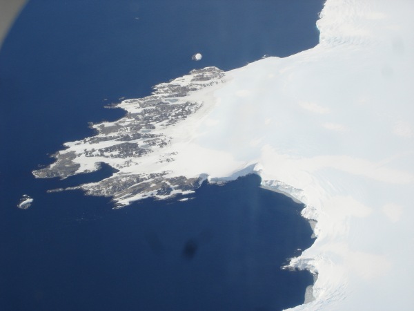
- Caption
- Cape Denison from the air.
- Photographer
- Ryan, Ursula
Map
Source
)
Comments
NoneApproval status
Display Scales
For example, selecting 'Aus_display_scale_20M' would only return names that would appear on a 1:20 million scale map.
| Aus_display_scale_20M: | No | Aus_display_scale_10M: | No | ||
| Aus_display_scale_5M: | No | Aus_display_scale_2M: | Yes | ||
| Aus_display_scale_1M: | Yes | Aus_display_scale_500k: | Yes | ||
| Aus_display_scale_250k: | Yes | Aus_display_scale_100k: | Yes | ||
| Aus_display_scale_50k: | No | Aus_display_scale_25k: | No | ||
| Aus_display_scale_10k: | Yes | Aus_display_scale_5k: | No | ||
| Aus_display_scale_1k: | No |
Related information
Biodiversity
View
fauna,
flora or
both
within 1.0 degree of this location
Place names
View
Australian or
international
place names within 1.0 degree of this location.