Vestfold Hills
Vestfold Hills (The name as it would appear in a gazetteer)
Vestfold Hills (The name as it would appear on a map)
If this information is incorrect, please e-mail mapping@aad.gov.au
Place ID: 15439
Name ID: 133224
Feature type:
Hill
(2b)
Origin
This name originates from United States of America.
It is part of the
United States Gazetteer and the SCAR Composite Gazetteer of Antarctica.
Names that other countries have for this feature:
Narrative
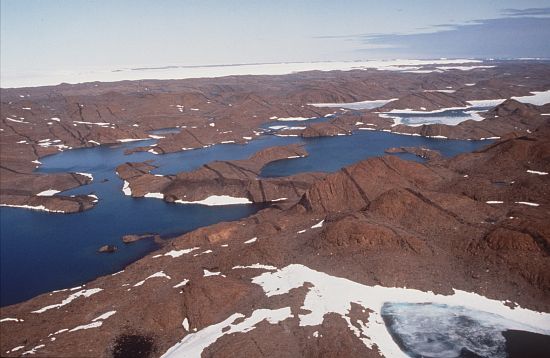
An area of rounded rock coastal hills, 200 square mi in extent, located at the N side of Sorsdal Glacier on Ingrid Christensen Coast. The hills are subdivided by three west-trending peninsulas bounded by narrow fjords. Most of the hills range between 30 and 90 meters, the highest summit being nearly 160 meters. Discovered and a landing made in the northern portion, Feb. 20, 1935, by Capt. Klarius Mikkelsen in the Norwegian whaling ship Thorshavn sent out by Lars Christensen. Named after Vestfold, a county in Norway where Sandefjord, headquarters of the whaling industry is located. This hill area and its off-lying islands were mapped from air photos taken by the Lars Christensen Expedition (1936-37). Further brief landings were made by Lincoln Ellsworth in 1939, and the area was photographed from the air by USN Operation Highjump (1946-47). Landings were made and exploration carried out in 1954 and 1955 by ANARE led by Phillip Law. Davis Station was established by ANARE in January 1957.
Named For
Location
Latitude:
68° 33' 00.0" S
-68.55000°
Unknown precision
Longitude:
78° 15' 00.0" E
78.25000°
Unknown precision
Altitude:
Not recorded
Unknown precision
Images
©AAD, Copyright Commonwealth of Australia 1993
- Catalogue id
- 2274B1
- Photographer
- Goddard, Jane
Map
Source
Source Institution:
Unknown
Source Publisher:
Unknown
Remote sensing:
Not Applicable
Comments
None
Approval status
Date approved:
1-Jan-1947
Related information