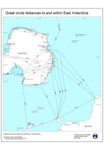
Map 11105: Great circle distances to and within East Antarctica (nautical miles)
Map details
| Map Number | 11105 |
| Title | Great circle distances to and within East Antarctica (nautical miles) |
| Edition | 1 |
| Scale | 1 : 27 000 000 |
| Publication date | June 1999 |
| Publisher |
Australian Antarctic Division (Australia)
|
| Spatial coverage |
(-180.0000° -30.0000°)
,
(180.0000° -30.0000°)
,
(180.0000° -90.0000°)
(-180.0000° -90.0000°) |
| Projection | Polar Stereographic |
| Physical size | 29.7 x 21 cm |
| Notes |
Distances are in nautical miles. The map is included in the publication "Antarctic Air Transport Scoping Study" by James Shevlin and Joe Johnson, July 1999. |
| Keywords | Topographic |
Downloads
This is a digital map available for downloading.
Map Lists
This map belongs to the following lists. Use the link on the list to see all maps belonging to that list
Additional Information
| Horizontal datum | WGS84 |
Preview