Map 1544: Distribution of Birds, Heard Island 1951
Map details
| Map Number | 1544 |
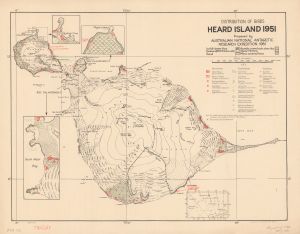
| Title | Distribution of Birds, Heard Island 1951 |
| Edition | 1 |
| Scale | 1 : 82 286 |
| Publication date | 1952 |
| Publisher |
Australia
|
| Spatial coverage |
( 73.2500° -52.9500°)
,
( 73.8667° -52.9500°)
,
( 73.8667° -53.2500°)
( 73.2500° -53.2500°) |
| Projection | Not Given |
| Physical size | 43 x 55.5 cm |
| Notes |
Prepared by the Australian National Antarctic Research Expedition 1951; reproduced by Royal Australian Survey Corps Insets: Sydney Cove, Rogers Head, South West Bay and the location of Heard Island in relation to Antarctica and other subantarctic islands. |
| Reference | AHQ/A6-12/0242 |
| Keywords | Penguin , petrel , tern , skua , cormorant , prion , pigeon , sheathbill , mollymawk , albatross , Heard Island , bird , azorella , glacial , glacier , lava |
Downloads
This is a hard copy map that has been scanned. See information about obtaining copies of hard copy maps.
Map Lists
No maps lists available.
Additional Information
Preview