Name details
Xianggang Dao
Xianggang Dao (The name as it would appear in a gazetteer)
Xianggang Dao (The name as it would appear on a map)
If this information is incorrect, please e-mail mapping@aad.gov.au
Feature type: Island
Origin
This name originates from China. It is part of the China Gazetteer and the SCAR Composite Gazetteer of Antarctica.
Names that other countries have for this feature:
- McLeod Island (Australia)
Narrative
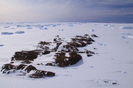
A bare rock island on the northwest of Wa Dao and Mihun Dao, also the second largest island in the northern sea of Larsemann Hill. It covers a total area of approximately 1.1 square meters. Precipitous rocks could be seen all along the shore of the island, but the land on the island is rather even. There is a fresh water pond on the northern end and the middle part of the southern part of the island each. It was named when aerial photos surveying and mapping in 1993.
Named For
Location
Images
©Rick Oates 2009
- Catalogue id
- IA21805
- Caption
- McLeod Island, Larsemann Hills. Taken from helicopter at height of 1500 feet. Looking South.
- Photographer
- Oates, Rick
Map
Source
Comments
Name (formerly Xiaoxianggang Dao), coordinates, date named and narrative updated as of request by Songtao Ai of 5 June 2015 (J. Muller)Approval status
Display Scales
For example, selecting 'Aus_display_scale_20M' would only return names that would appear on a 1:20 million scale map.
| Aus_display_scale_20M: | Yes | Aus_display_scale_10M: | Yes | ||
| Aus_display_scale_5M: | No | Aus_display_scale_2M: | Yes | ||
| Aus_display_scale_1M: | Yes | Aus_display_scale_500k: | Yes | ||
| Aus_display_scale_250k: | Yes | Aus_display_scale_100k: | Yes | ||
| Aus_display_scale_50k: | Yes | Aus_display_scale_25k: | Yes | ||
| Aus_display_scale_10k: | Yes | Aus_display_scale_5k: | Yes | ||
| Aus_display_scale_1k: | Yes |
Related information
Biodiversity
View
fauna,
flora or
both
within 1.0 degree of this location
Place names
View
Chinese or
international
place names within 1.0 degree of this location.