Name details
Barkell Platform
Barkell Platform (The name as it would appear in a gazetteer)
Barkell Platform (The name as it would appear on a map)
If this information is incorrect, please e-mail mapping@aad.gov.au
Feature type: Platform (2h)
Origin
This name originates from United States of America. It is part of the United States Gazetteer and the SCAR Composite Gazetteer of Antarctica.
Names that other countries have for this feature:
- Barkell Platform (Australia)
- Barkell Platform (Russia)
Narrative
A narrow, level rock platform on the N end of Mawson Escarpment. This promontory, 1,285 m high, was the site of a geodetic survey station during the ANARE Prince Charles Mountains survey in 1971. Named for V.G. Barkell, helicopter pilot with the survey.
Named For
Location
Images
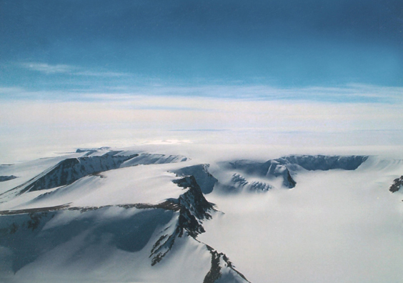
©Helicopter Resources pilot- Ricardo Piacenza 2004
- Catalogue id
- IA16637
- Caption
- A narrow level rock platform about 100 metres wide on the north end of the Mawson Escarpment - the site of geodetic survey station during a PCM survey 1971
- Photographer
- Piacenza, Ricardo
Map
Source
Comments
NoneApproval status
Display Scales
For example, selecting 'Aus_display_scale_20M' would only return names that would appear on a 1:20 million scale map.
| Aus_display_scale_20M: | No | Aus_display_scale_10M: | No | ||
| Aus_display_scale_5M: | No | Aus_display_scale_2M: | No | ||
| Aus_display_scale_1M: | No | Aus_display_scale_500k: | No | ||
| Aus_display_scale_250k: | No | Aus_display_scale_100k: | No | ||
| Aus_display_scale_50k: | No | Aus_display_scale_25k: | No | ||
| Aus_display_scale_10k: | No | Aus_display_scale_5k: | No | ||
| Aus_display_scale_1k: | No |
Related information
Biodiversity
View
fauna,
flora or
both
within 1.0 degree of this location
Place names
View
American or
international
place names within 1.0 degree of this location.