Name details
Barrier Island
Barrier Island (The name as it would appear in a gazetteer)
Barrier Island (The name as it would appear on a map)
If this information is incorrect, please e-mail mapping@aad.gov.au
Feature type: Island (5)
Origin
This name originates from United States of America. It is part of the United States Gazetteer and the SCAR Composite Gazetteer of Antarctica.
Names that other countries have for this feature:
- Barrier Island (Australia)
- Barrier Island (Russia)
Narrative
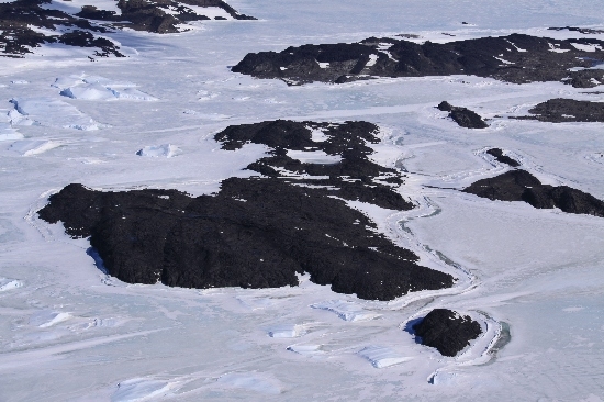
An island, 0.5 mi long, at the N end of the Vestfold Hills, lying just N of the entrance to Tryne Fjord in Tryne Sound. Mapped by Norwegian cartographers from air photos taken by the Lars Christensen Expedition, 1936-37. Visited in 1957 by an ANARE party and so named because the island appeared to form a barrier to the passage of icebergs up Tryne Fjord.
Named For
Location
Images
©Belinda Reynolds 2009
- Catalogue id
- IA21846
- Caption
- Barrier Island, Vestfold Hills. Taken from helicopter at height of 1000 feet. Looking West.
- Photographer
- Reynolds, Belinda
Map
Source
Comments
NoneApproval status
Display Scales
For example, selecting 'Aus_display_scale_20M' would only return names that would appear on a 1:20 million scale map.
| Aus_display_scale_20M: | No | Aus_display_scale_10M: | No | ||
| Aus_display_scale_5M: | No | Aus_display_scale_2M: | No | ||
| Aus_display_scale_1M: | No | Aus_display_scale_500k: | No | ||
| Aus_display_scale_250k: | No | Aus_display_scale_100k: | No | ||
| Aus_display_scale_50k: | No | Aus_display_scale_25k: | No | ||
| Aus_display_scale_10k: | No | Aus_display_scale_5k: | No | ||
| Aus_display_scale_1k: | No |
Related information
Biodiversity
View
fauna,
flora or
both
within 1.0 degree of this location
Place names
View
American or
international
place names within 1.0 degree of this location.