Name details
Lake Franzmann
Franzmann, Lake (The name as it would appear in a gazetteer)
Lake Franzmann (The name as it would appear on a map)
If this information is incorrect, please e-mail mapping@aad.gov.au
Feature type: Water body
Origin
This name originates from Australia. It is part of the Australian Antarctic Gazetteer and the SCAR Composite Gazetteer of Antarctica.
Narrative
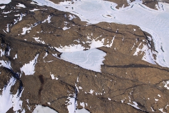
Lake Franzmann is a saline lake approximately 400 m by 150 m in area on the northern shore of Long Fjord in the Vestfold Hills. The lake surface is only marginally above sea-level, and water flows into and from the lake at very high tide during summer. The maximum recorded depth is 8 m. The lake is permanently stratified and therefore meromictic. Little is known about the biology of Lake Franzmann although a wide variety of planktonic diatoms have been observed in the lake in poor condition. These were probably a result of marine water inflow. Similarly, one or two species of harpacticoid copepod have been found in the lake during winter although no live samples have been obtained.
Named For
Lake Franzmann is named after Dr Peter Franzmann who wintered at Davis in 1984. During this year Dr Franzmann studied the bacteria of and microbiological processes in a number of lakes. He subsequently spent another summer at Davis (1987-8) during which time he studied methane production in Ace Lake. Since his winter he has been heavily involved in the taxonomy and ecology of saline lake bacteria of the Vestfold Hills.
Location
Images
©Belinda Reynolds 2009
- Catalogue id
- IA21920
- Caption
- Lake Franzmann, Vestfold Hills. Taken from helicopter at height of 1800 feet. Looking Southeast.
- Photographer
- Reynolds, Belinda
Map
Source
Comments
Metadata for coordinates and origin of topographic data.Approval status
Display Scales
For example, selecting 'Aus_display_scale_20M' would only return names that would appear on a 1:20 million scale map.
| Aus_display_scale_20M: | No | Aus_display_scale_10M: | No | ||
| Aus_display_scale_5M: | No | Aus_display_scale_2M: | No | ||
| Aus_display_scale_1M: | No | Aus_display_scale_500k: | No | ||
| Aus_display_scale_250k: | No | Aus_display_scale_100k: | No | ||
| Aus_display_scale_50k: | Yes | Aus_display_scale_25k: | No | ||
| Aus_display_scale_10k: | No | Aus_display_scale_5k: | No | ||
| Aus_display_scale_1k: | No |
Related information
Biodiversity
View
fauna,
flora or
both
within 1.0 degree of this location
Place names
View
Australian or
international
place names within 1.0 degree of this location.