Name details
Holl Island
Holl Island (The name as it would appear in a gazetteer)
Holl Island (The name as it would appear on a map)
If this information is incorrect, please e-mail mapping@aad.gov.au
Feature type: Island (5)
Origin
This name originates from United States of America. It is part of the United States Gazetteer and the SCAR Composite Gazetteer of Antarctica.
Names that other countries have for this feature:
- Holl Island (Australia)
- Holl Island (Russia)
Narrative
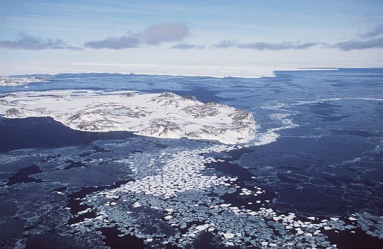
Rocky, triangular-shaped island, 1.7 mi long, marking the SW end of the Windmill Islands. Mapped from aerial photographs taken by USN Operation HighJump, 1946-47, and USN Operation Windmill, 1947-48. Named by the US-ACAN for Lt. Richard C. Holl, USNR, photogrammetrist with the Navy Hydrographic Office, who served as surveyor with the USN Operation Windmill parties which established astronomical control stations on Holl Island and along Queen Mary and Knox Coasts.
Named For
Location
Images
©AAD, Copyright Commonwealth of Australia 1998
- Catalogue id
- 3424B5
- Photographer
- Dixon, Grant
Map
Source
Comments
NoneApproval status
Display Scales
For example, selecting 'Aus_display_scale_20M' would only return names that would appear on a 1:20 million scale map.
| Aus_display_scale_20M: | No | Aus_display_scale_10M: | No | ||
| Aus_display_scale_5M: | No | Aus_display_scale_2M: | No | ||
| Aus_display_scale_1M: | No | Aus_display_scale_500k: | No | ||
| Aus_display_scale_250k: | No | Aus_display_scale_100k: | No | ||
| Aus_display_scale_50k: | No | Aus_display_scale_25k: | No | ||
| Aus_display_scale_10k: | No | Aus_display_scale_5k: | No | ||
| Aus_display_scale_1k: | No |
Related information
Biodiversity
View
fauna,
flora or
both
within 1.0 degree of this location
Place names
View
American or
international
place names within 1.0 degree of this location.