Name details
Krok Lake
Krok Lake (The name as it would appear in a gazetteer)
Krok Lake (The name as it would appear on a map)
If this information is incorrect, please e-mail mapping@aad.gov.au
Feature type: Water body (11)
Origin
This name originates from United States of America. It is part of the United States Gazetteer and the SCAR Composite Gazetteer of Antarctica.
Names that other countries have for this feature:
- Crooked Lake (Australia)
- Krokvatnet (Russia)
Narrative
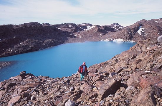
An irregular-shaped lake about 4 mi long in the SE part of the Vestfold Hills. The lake was partially mapped by Norwegian cartographers from air photos taken by the Lars Christensen Expedition (1936-37) and named Krokvatnet (the crooked lake). The lake was mapped in its entirety by ANARE, utilizing air photos taken in 1957-58.
Named For
Location
Images
©AAD, Copyright Commonwealth of Australia 1998
- Catalogue id
- 2620C5
- Photographer
- Cianchi, Andrew (Andy)
Map
Source
Comments
NoneApproval status
Display Scales
For example, selecting 'Aus_display_scale_20M' would only return names that would appear on a 1:20 million scale map.
| Aus_display_scale_20M: | No | Aus_display_scale_10M: | No | ||
| Aus_display_scale_5M: | No | Aus_display_scale_2M: | No | ||
| Aus_display_scale_1M: | No | Aus_display_scale_500k: | No | ||
| Aus_display_scale_250k: | No | Aus_display_scale_100k: | No | ||
| Aus_display_scale_50k: | No | Aus_display_scale_25k: | No | ||
| Aus_display_scale_10k: | No | Aus_display_scale_5k: | No | ||
| Aus_display_scale_1k: | No |
Related information
Biodiversity
View
fauna,
flora or
both
within 1.0 degree of this location
Place names
View
American or
international
place names within 1.0 degree of this location.