Name details
Langnes Fjord
Langnes Fjord (The name as it would appear in a gazetteer)
Langnes Fjord (The name as it would appear on a map)
If this information is incorrect, please e-mail mapping@aad.gov.au
Feature type: Fjord (3)
Origin
This name originates from United States of America. It is part of the United States Gazetteer and the SCAR Composite Gazetteer of Antarctica.
Names that other countries have for this feature:
- Langnes Fjord (Russia)
- Long Fjord (Australia)
Narrative
A narrow fjord, 10 mi long, between Langnes Peninsula and Breidnes Peninsula in the Vestfold Hills. Mapped from air photos by the Lars Christensen Expedition (1936-37) and named after Langnes Peninsula. John Roscoe's 1952 study of air photos taken by USN Operation Highjump (1946-47) revealed that this fjord continues farther east than was previously mapped, and that it includes what had been plotted as an isolated lake which the Norwegians had called "Breidvatnet."
Named For
Location
Images
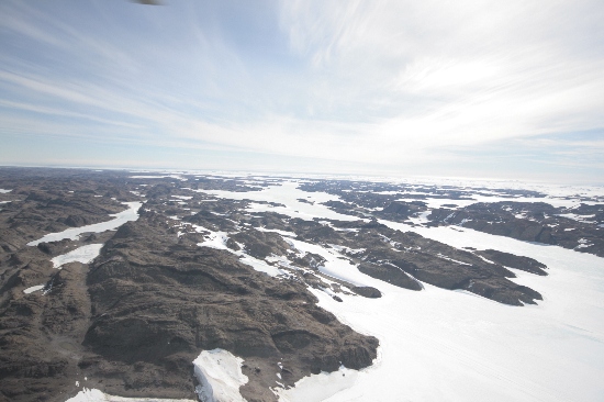
©Nathan Saunders 2009
- Catalogue id
- IA21937
- Caption
- Long Fjord, Vestfold Hills. Taken from helicopter at height of 1500 feet. Looking West.
- Photographer
- Saunders, Nathan
Map
Source
Comments
NoneApproval status
Display Scales
For example, selecting 'Aus_display_scale_20M' would only return names that would appear on a 1:20 million scale map.
| Aus_display_scale_20M: | No | Aus_display_scale_10M: | No | ||
| Aus_display_scale_5M: | No | Aus_display_scale_2M: | No | ||
| Aus_display_scale_1M: | No | Aus_display_scale_500k: | No | ||
| Aus_display_scale_250k: | No | Aus_display_scale_100k: | No | ||
| Aus_display_scale_50k: | No | Aus_display_scale_25k: | No | ||
| Aus_display_scale_10k: | No | Aus_display_scale_5k: | No | ||
| Aus_display_scale_1k: | No |
Related information
Biodiversity
View
fauna,
flora or
both
within 1.0 degree of this location
Place names
View
American or
international
place names within 1.0 degree of this location.