Name details
North Masson Range
North Masson Range (The name as it would appear in a gazetteer)
North Masson Range (The name as it would appear on a map)
If this information is incorrect, please e-mail mapping@aad.gov.au
Feature type: Range (2c)
Origin
This name originates from United States of America. It is part of the United States Gazetteer and the SCAR Composite Gazetteer of Antarctica.
Names that other countries have for this feature:
- Nordkammen (Russia)
- North Masson Range (Australia)
Narrative
The Masson Range is divided into three parts of which this segment is the northern, rising to 1,030 m and extending 3 mi in a N-S direction. The Masson Range was discovered and named by BANZARE, 1929-31, under Mawson. This northern range was mapped by Norwegian cartographers from air photos taken by the Lars Christensen Expedition, 1936-37, and named Nordkammen (the north comb or crest). The approved name, suggested by ANCA in 1960, more clearly identifies the feature as a part of Masson Range.
Named For
Location
Images
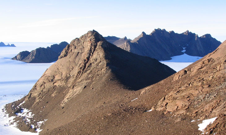
©Mel Fitzpatrick 2003
- Catalogue id
- IA16476
- Caption
- Looking north at the North Masson range from the Central Masson Range. The foreground shows the typical terrain of steep slopes covered in rocks and loose scree.
- Photographer
- Fitzpatrick, Mel
Map
Source
Comments
NoneApproval status
Display Scales
For example, selecting 'Aus_display_scale_20M' would only return names that would appear on a 1:20 million scale map.
| Aus_display_scale_20M: | No | Aus_display_scale_10M: | No | ||
| Aus_display_scale_5M: | No | Aus_display_scale_2M: | No | ||
| Aus_display_scale_1M: | No | Aus_display_scale_500k: | No | ||
| Aus_display_scale_250k: | No | Aus_display_scale_100k: | No | ||
| Aus_display_scale_50k: | No | Aus_display_scale_25k: | No | ||
| Aus_display_scale_10k: | No | Aus_display_scale_5k: | No | ||
| Aus_display_scale_1k: | No |
Related information
Biodiversity
View
fauna,
flora or
both
within 1.0 degree of this location
Place names
View
American or
international
place names within 1.0 degree of this location.