Name details
Odbert Island
Odbert Island (The name as it would appear in a gazetteer)
Odbert Island (The name as it would appear on a map)
If this information is incorrect, please e-mail mapping@aad.gov.au
Feature type: Island (5)
Origin
This name originates from United States of America. It is part of the United States Gazetteer and the SCAR Composite Gazetteer of Antarctica.
Names that other countries have for this feature:
- Odbert Island (Australia)
- Odbert Island (Russia)
Narrative
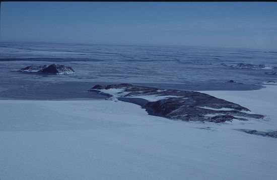
Rocky island, 1.5 mi long, between Ardery Island and Robinson Ridge in the Windmill Islands. First mapped from air photos taken by USN Operation HighJump and Operation Windmill in 1947 and 1948. Named by the US-ACAN for Lt. Jack A. Odbert, USN, assistant aerological officer with USN Operation Windmill which established astronomical control stations in the area in January 1948.
Named For
Location
Images
©Woehler, Eric 2001
- Catalogue id
- 4950B3
- Caption
- Ardery Island (Left) Obert Island (right)
- Photographer
- Woehler, Eric
Map
Source
Comments
NoneApproval status
Display Scales
For example, selecting 'Aus_display_scale_20M' would only return names that would appear on a 1:20 million scale map.
| Aus_display_scale_20M: | No | Aus_display_scale_10M: | No | ||
| Aus_display_scale_5M: | No | Aus_display_scale_2M: | No | ||
| Aus_display_scale_1M: | No | Aus_display_scale_500k: | No | ||
| Aus_display_scale_250k: | No | Aus_display_scale_100k: | No | ||
| Aus_display_scale_50k: | No | Aus_display_scale_25k: | No | ||
| Aus_display_scale_10k: | No | Aus_display_scale_5k: | No | ||
| Aus_display_scale_1k: | No |
Related information
Biodiversity
View
fauna,
flora or
both
within 1.0 degree of this location
Place names
View
American or
international
place names within 1.0 degree of this location.