Name details
Soldat Island
Soldat Island (The name as it would appear in a gazetteer)
Soldat Island (The name as it would appear on a map)
If this information is incorrect, please e-mail mapping@aad.gov.au
Feature type: Island (5)
Origin
This name originates from United States of America. It is part of the United States Gazetteer and the SCAR Composite Gazetteer of Antarctica.
Names that other countries have for this feature:
- Soldat Island (Australia)
- Soldat, ostrov (Russia)
Narrative
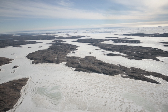
An elongated rocky island, 2.5 mi long, lying S of Partizan Island in the S part of the entrance to Langnes Fjord, Vestfold Hills. This feature was photographed by the Lars Christensen Expedition (1936-37), but was plotted on the subsequent maps as a peninsula. It was first shown to be an island by John Roscoe's 1952 study of aerial photographs of the area taken by USN Operation Highjump (1946-47). The area was photographed by ANARE (1954-58) and the SovAE (1956), the latter applying the name Ostrov Soldat (soldier island).
Named For
Location
Images
©Nathan Saunders 2009
- Catalogue id
- IA21994
- Caption
- Soldat Island, Vestfold Hills. Taken from helicopter at height of 3000 feet. Looking West.
- Photographer
- Saunders, Nathan
Map
Source
Comments
NoneApproval status
Display Scales
For example, selecting 'Aus_display_scale_20M' would only return names that would appear on a 1:20 million scale map.
| Aus_display_scale_20M: | No | Aus_display_scale_10M: | No | ||
| Aus_display_scale_5M: | No | Aus_display_scale_2M: | No | ||
| Aus_display_scale_1M: | No | Aus_display_scale_500k: | No | ||
| Aus_display_scale_250k: | No | Aus_display_scale_100k: | No | ||
| Aus_display_scale_50k: | No | Aus_display_scale_25k: | No | ||
| Aus_display_scale_10k: | No | Aus_display_scale_5k: | No | ||
| Aus_display_scale_1k: | No |
Related information
Biodiversity
View
fauna,
flora or
both
within 1.0 degree of this location
Place names
View
American or
international
place names within 1.0 degree of this location.