Name details
Taynaya Bay
Taynaya Bay (The name as it would appear in a gazetteer)
Taynaya Bay (The name as it would appear on a map)
If this information is incorrect, please e-mail mapping@aad.gov.au
Feature type: Bay (3)
Origin
This name originates from United States of America. It is part of the United States Gazetteer and the SCAR Composite Gazetteer of Antarctica.
Names that other countries have for this feature:
- Tajnaja, buhta (Russia)
- Taynaya Bay (Australia)
Narrative
A bay which is completely enclosed except for a very narrow entrance on the north side, lying within the northern part of Langnes Peninsula, Vestfold Hills. The feature was photographed by the Lars Christensen Expedition (1936-37), but was plotted on the subsequent maps as a lake. John Roscoe's 1952 study of air photographs taken by Operation Highjump (1946-47) showed that the bay is connected at the north to the sea. It was photographed by ANARE (1954-58) and the Soviet Antarctic Expedition (1956), the latter applying the name Bukhta Taynaya (secret bay).
Named For
Location
Images
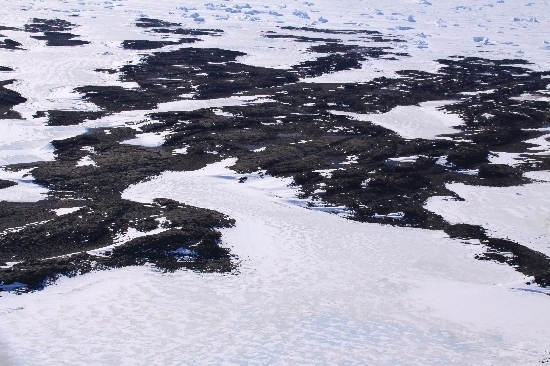
©Belinda Reynolds 2009
- Catalogue id
- IA22009
- Caption
- Taynaya Bay, Vestfold Hills. Taken from helicopter at height of 1200 feet. Looking North.
- Photographer
- Reynolds, Belinda
Map
Source
Comments
NoneApproval status
Display Scales
For example, selecting 'Aus_display_scale_20M' would only return names that would appear on a 1:20 million scale map.
| Aus_display_scale_20M: | No | Aus_display_scale_10M: | No | ||
| Aus_display_scale_5M: | No | Aus_display_scale_2M: | No | ||
| Aus_display_scale_1M: | No | Aus_display_scale_500k: | No | ||
| Aus_display_scale_250k: | No | Aus_display_scale_100k: | No | ||
| Aus_display_scale_50k: | No | Aus_display_scale_25k: | No | ||
| Aus_display_scale_10k: | No | Aus_display_scale_5k: | No | ||
| Aus_display_scale_1k: | No |
Related information
Biodiversity
View
fauna,
flora or
both
within 1.0 degree of this location
Place names
View
American or
international
place names within 1.0 degree of this location.