Name details
Ufs Island
Ufs Island (The name as it would appear in a gazetteer)
Ufs Island (The name as it would appear on a map)
If this information is incorrect, please e-mail mapping@aad.gov.au
Feature type: Island (5)
Origin
This name originates from United States of America. It is part of the United States Gazetteer and the SCAR Composite Gazetteer of Antarctica.
Names that other countries have for this feature:
- Ufs Island (Australia)
Narrative
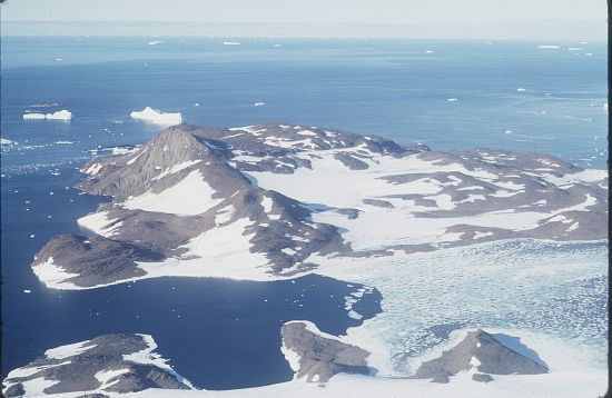
A rocky island 2 mi wide, lying in the E part of Howard Bay. Cape Simpson, the N end of this island, was discovered by the BANZARE under Mawson in February 1931, but the feature's insularity was first recognized by Norwegian cartographers working from aerial photographs taken by the Lars Christensen Expedition, 1936-37. They named it Ufsoy (bluff island).
Named For
Location
Images
©AAD, Copyright Commonwealth of Australia 1972
- Catalogue id
- 516A5
- Caption
- In the eastern part of Howard Bay. Called Ufsoy by the Norwegians, meaning Bluff Island
- Photographer
- Manning, John
Map
Source
Comments
NoneApproval status
Display Scales
For example, selecting 'Aus_display_scale_20M' would only return names that would appear on a 1:20 million scale map.
| Aus_display_scale_20M: | No | Aus_display_scale_10M: | No | ||
| Aus_display_scale_5M: | No | Aus_display_scale_2M: | No | ||
| Aus_display_scale_1M: | No | Aus_display_scale_500k: | No | ||
| Aus_display_scale_250k: | No | Aus_display_scale_100k: | No | ||
| Aus_display_scale_50k: | No | Aus_display_scale_25k: | No | ||
| Aus_display_scale_10k: | No | Aus_display_scale_5k: | No | ||
| Aus_display_scale_1k: | No |
Related information
Biodiversity
View
fauna,
flora or
both
within 1.0 degree of this location
Place names
View
American or
international
place names within 1.0 degree of this location.