Name details
Lake Vereteno
Vereteno, Lake (The name as it would appear in a gazetteer)
Lake Vereteno (The name as it would appear on a map)
If this information is incorrect, please e-mail mapping@aad.gov.au
Feature type: Water body (11)
Origin
This name originates from United States of America. It is part of the United States Gazetteer and the SCAR Composite Gazetteer of Antarctica.
Names that other countries have for this feature:
- Vereteno Lake (Australia)
- Vereteno, ozero (Russia)
Narrative
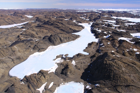
A narrow lake, 1.5 mi long, located in the NE part of Breidnes Peninsula, Vestfold Hills, approximately 1.5 mi S of Luncke Ridge. The lake was first photographed by USN Operation Highjump (1946-47), and subsequently by ANARE (1954-58), and the Soviet Antarctic Expedition (1956). Named Ozero Veretenu (spindle lake) by the latter.
Named For
Location
Images
©Richard 'Tubby' Seton 2009
- Catalogue id
- IA22033
- Caption
- Vereteno Lake, Vestfold Hills. Taken from helicopter at height of 1000 feet. Looking West.
- Photographer
- Seton, Richard
Map
Source
Comments
NoneApproval status
Display Scales
For example, selecting 'Aus_display_scale_20M' would only return names that would appear on a 1:20 million scale map.
| Aus_display_scale_20M: | No | Aus_display_scale_10M: | No | ||
| Aus_display_scale_5M: | No | Aus_display_scale_2M: | No | ||
| Aus_display_scale_1M: | No | Aus_display_scale_500k: | No | ||
| Aus_display_scale_250k: | No | Aus_display_scale_100k: | No | ||
| Aus_display_scale_50k: | No | Aus_display_scale_25k: | No | ||
| Aus_display_scale_10k: | No | Aus_display_scale_5k: | No | ||
| Aus_display_scale_1k: | No |
Related information
Biodiversity
View
fauna,
flora or
both
within 1.0 degree of this location
Place names
View
American or
international
place names within 1.0 degree of this location.