Name details
Mount Harding
Harding, Mount (The name as it would appear in a gazetteer)
Mount Harding (The name as it would appear on a map)
If this information is incorrect, please e-mail mapping@aad.gov.au
Feature type: Mountain
Origin
This name originates from Australia. It is part of the Australian Antarctic Gazetteer and the SCAR Composite Gazetteer of Antarctica.
Names that other countries have for this feature:
- Mount Harding (Russia)
- Mount Harding (United States of America)
Narrative
The largest mountain in the Grove Mountains, Princess Elizabeth Land. Plotted from ANARE air photographs. Named after N.E. Harding, a senior topographic draughtsman with the (then) Division of National Mapping of the Australian Department of National Development.
Named For
Named after N.E. Harding, a senior topographic draughtsman with the (then) Division of National Mapping of the Australian Department of National Development.
Location
Images
©Adrian Corvino 2004
- Catalogue id
- IA16611
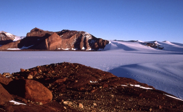
- Caption
- Mount Harding is the highest pointed peak about a fifth of the way in from the left hand side of the photo. The photo was taken at about midnight from Tianhe Range (nunatak) about 3.5 kilometres south west of Mount Harding. Note the GPS base station wind generator in the middle and centre of the photo. Zakharoff Ridge is on the right and centre of the photo.
- Photographer
- Corvino, Adrian
Map
Source
Comments
NoneApproval status
Display Scales
For example, selecting 'Aus_display_scale_20M' would only return names that would appear on a 1:20 million scale map.
| Aus_display_scale_20M: | No | Aus_display_scale_10M: | No | ||
| Aus_display_scale_5M: | No | Aus_display_scale_2M: | Yes | ||
| Aus_display_scale_1M: | Yes | Aus_display_scale_500k: | Yes | ||
| Aus_display_scale_250k: | Yes | Aus_display_scale_100k: | Yes | ||
| Aus_display_scale_50k: | Yes | Aus_display_scale_25k: | No | ||
| Aus_display_scale_10k: | No | Aus_display_scale_5k: | No | ||
| Aus_display_scale_1k: | No |
Related information
Biodiversity
View
fauna,
flora or
both
within 1.0 degree of this location
Place names
View
Australian or
international
place names within 1.0 degree of this location.