Name details
Streeter Bluff
Streeter Bluff (The name as it would appear in a gazetteer)
Streeter Bluff (The name as it would appear on a map)
If this information is incorrect, please e-mail mapping@aad.gov.au
Feature type: Bluff
Origin
This name originates from Australia. It is part of the Australian Antarctic Gazetteer.
Narrative
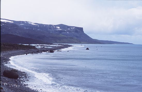
A rolling rocky hill on Heard Island about 200 m high with a steep drop to the north east. This trig station, Forward 2, was established by RG Dovers in 1948. It was located and photographed by Rod Streeter, Surveyor with the National Mapping Expedition to Heard Island in 1980.
Named For
Location
Images
©AAD, Copyright Commonwealth of Australia 2004
- Catalogue id
- 4836A3
- Caption
- View from Try Pot Beach looking north to Streeter Bluff
- Photographer
- Woehler, Eric
Map
Source
Comments
NoneApproval status
Display Scales
For example, selecting 'Aus_display_scale_20M' would only return names that would appear on a 1:20 million scale map.
| Aus_display_scale_20M: | No | Aus_display_scale_10M: | No | ||
| Aus_display_scale_5M: | No | Aus_display_scale_2M: | No | ||
| Aus_display_scale_1M: | No | Aus_display_scale_500k: | No | ||
| Aus_display_scale_250k: | No | Aus_display_scale_100k: | No | ||
| Aus_display_scale_50k: | No | Aus_display_scale_25k: | No | ||
| Aus_display_scale_10k: | No | Aus_display_scale_5k: | No | ||
| Aus_display_scale_1k: | No |
Related information
Biodiversity
View
fauna,
flora or
both
within 1.0 degree of this location
Place names
View
Australian or
international
place names within 1.0 degree of this location.