Name details
Azorella Peninsula
Azorella Peninsula (The name as it would appear in a gazetteer)
Azorella Peninsula (The name as it would appear on a map)
If this information is incorrect, please e-mail mapping@aad.gov.au
Feature type: Peninsula
Origin
This name originates from Australia. It is part of the Australian Antarctic Gazetteer.
Narrative
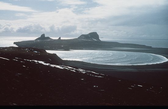
The peninsula on Heard Island extending to Rogers Head, between Corinthian Bay and Atlas Cove.
Named For
Location
Latitude:
53° 00' 47.5" S
-53.01319°
Accurate to 20m
Longitude:
73° 24' 08.6" E
73.40239°
Accurate to 20m
Altitude:
40 m
Unknown precision
Images
©AAD, Copyright Commonwealth of Australia 1985
- Catalogue id
- 1896A2
- Caption
- View from Mt Andre
- Photographer
- Williams, Lynn
Map
Source
Location Method:
Georeferenced Satellite Image
Source Name:
World View 23/3/2008 Satellite Cat ID 1958
Source Identifier:
Source Scale:
1:5000
Source Institution:
Australian Antarctic Division
Source Person:
Brolsma
Source Publisher:
DigitalGlobe
Remote sensing:
Not Applicable
Comments
NoneApproval status
Status:
Official
Date approved:
3-Dec-1982
Display Scales
Note These display scales were chosen for use by Australia, with an emphasis on East Antarctica.
For example, selecting 'Aus_display_scale_20M' would only return names that would appear on a 1:20 million scale map.
For example, selecting 'Aus_display_scale_20M' would only return names that would appear on a 1:20 million scale map.
| Aus_display_scale_20M: | No | Aus_display_scale_10M: | No | ||
| Aus_display_scale_5M: | No | Aus_display_scale_2M: | No | ||
| Aus_display_scale_1M: | No | Aus_display_scale_500k: | No | ||
| Aus_display_scale_250k: | No | Aus_display_scale_100k: | No | ||
| Aus_display_scale_50k: | Yes | Aus_display_scale_25k: | No | ||
| Aus_display_scale_10k: | No | Aus_display_scale_5k: | No | ||
| Aus_display_scale_1k: | No |
Related information
Biodiversity
View
fauna,
flora or
both
within 1.0 degree of this location
Place names
View
Australian or
international
place names within 1.0 degree of this location.