Name details
Pickard Ridge
Pickard Ridge (The name as it would appear in a gazetteer)
Pickard Ridge (The name as it would appear on a map)
If this information is incorrect, please e-mail mapping@aad.gov.au
Feature type: Ridge
Origin
This name originates from Australia. It is part of the Australian Antarctic Gazetteer and the SCAR Composite Gazetteer of Antarctica.
Narrative
The ridge in the Vestfold Hills is irregular with a NNW-SSE orientation about 2.5 km long with an average width of about 0.6 km in the south and about 1 km in the north. Part of the feature is bounded by the 25 m contour which marks an old beach level. The ridge has an elevation of about 40 - 50m in the south rising to a little below 70 m in the north. It consists of ancient Precambrian rock and separates Marine Plain from Poseidon Basin and its southern extension. As defined Pickard Ridge includes a small isolated outcrop south of the ridge proper and separated from it by a 100 m gap.
Named For
It is named after John Pickard who wintered at Davis and who did initial studies describing the area and establishing its significance. John is the author of Antarctic Oasis the first attempt at a comprehensive synthesis of the evolution of the region in glacial times.
Location
Images
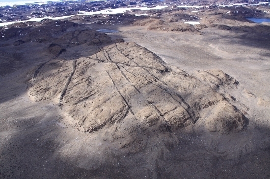
©Belinda Reynolds 2009
- Catalogue id
- IA21972
- Caption
- Pickard Ridge, Vestfold Hills. Taken from helicopter at height of 1200 feet. Looking North.
- Photographer
- Reynolds, Belinda
Map
Source
Comments
Metadata for coordinates and origin of topographic data.Approval status
Display Scales
For example, selecting 'Aus_display_scale_20M' would only return names that would appear on a 1:20 million scale map.
| Aus_display_scale_20M: | No | Aus_display_scale_10M: | No | ||
| Aus_display_scale_5M: | No | Aus_display_scale_2M: | No | ||
| Aus_display_scale_1M: | No | Aus_display_scale_500k: | No | ||
| Aus_display_scale_250k: | No | Aus_display_scale_100k: | No | ||
| Aus_display_scale_50k: | Yes | Aus_display_scale_25k: | Yes | ||
| Aus_display_scale_10k: | No | Aus_display_scale_5k: | No | ||
| Aus_display_scale_1k: | No |
Related information
Biodiversity
View
fauna,
flora or
both
within 1.0 degree of this location
Place names
View
Australian or
international
place names within 1.0 degree of this location.