Name details
Trajer Ridge
Trajer Ridge (The name as it would appear in a gazetteer)
Trajer Ridge (The name as it would appear on a map)
If this information is incorrect, please e-mail mapping@aad.gov.au
Feature type: Ridge
Origin
This name originates from Australia. It is part of the Australian Antarctic Gazetteer and the SCAR Composite Gazetteer of Antarctica.
Names that other countries have for this feature:
- Trajer Ridge (United States of America)
Narrative
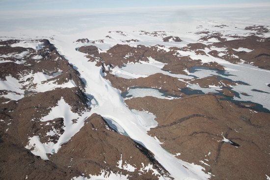
A rock ridge, about 125 m high, in the eastern part of the Vestfold Hills, about 6 km north of the eastern extremity of Crooked Lake. The region was photographed by USN Operation Highjump (1946-47), ANARE (1954, 1957 and 1958) and the Soviet Antarctic Expedition (1956).
Named For
Named after F.L. Trajer, weather observer at Davis in 1961, who with Dr. M. Hay first visited the feature on foot on 4 November, 1961.
Location
Images
©Nathan Saunders 2009
- Catalogue id
- IA22020
- Caption
- Trajer Ridge, Vestfold Hills. Taken from helicopter at height of 1500 feet. Looking Southeast.
- Photographer
- Saunders, Nathan
Map
Source
Comments
Metadata for coordinates and origin of topographic data.Approval status
Display Scales
For example, selecting 'Aus_display_scale_20M' would only return names that would appear on a 1:20 million scale map.
| Aus_display_scale_20M: | No | Aus_display_scale_10M: | No | ||
| Aus_display_scale_5M: | No | Aus_display_scale_2M: | No | ||
| Aus_display_scale_1M: | No | Aus_display_scale_500k: | No | ||
| Aus_display_scale_250k: | No | Aus_display_scale_100k: | No | ||
| Aus_display_scale_50k: | Yes | Aus_display_scale_25k: | Yes | ||
| Aus_display_scale_10k: | No | Aus_display_scale_5k: | No | ||
| Aus_display_scale_1k: | No |
Related information
Biodiversity
View
fauna,
flora or
both
within 1.0 degree of this location
Place names
View
Australian or
international
place names within 1.0 degree of this location.