Name details
Talg River
Talg River (The name as it would appear in a gazetteer)
Talg River (The name as it would appear on a map)
If this information is incorrect, please e-mail mapping@aad.gov.au
Feature type: Watercourse
Origin
This name originates from Australia. It is part of the Australian Antarctic Gazetteer and the SCAR Composite Gazetteer of Antarctica.
Narrative
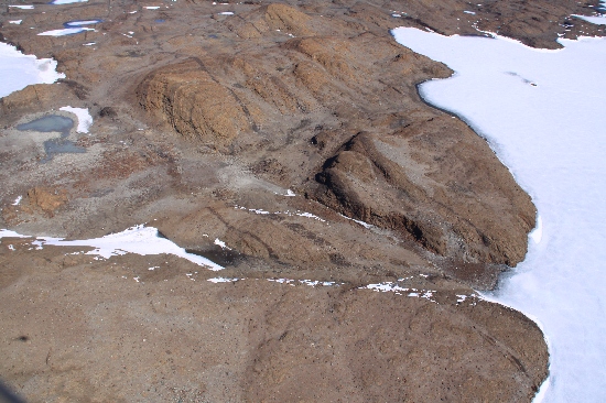
A major river in the Vestfold Hills draining from the Sørsdal Glacier into Crooked Lake. The flow in the melt season is torrential and occurs across ice and over an ice waterfall. The flow occurs in a well-defined meandering channel cut in the ice. Talg is Arabic for "ice".
Named For
Location
Images
©Richard 'Tubby' Seton 2009
- Catalogue id
- IA22006
- Caption
- Talg River, Vestfold Hills. Taken from helicopter at height of 1200 feet. Looking South.
- Photographer
- Seton, Richard
Map
Source
Comments
Metadata for coordinates and origin of topographic data.Approval status
Display Scales
For example, selecting 'Aus_display_scale_20M' would only return names that would appear on a 1:20 million scale map.
| Aus_display_scale_20M: | No | Aus_display_scale_10M: | No | ||
| Aus_display_scale_5M: | No | Aus_display_scale_2M: | No | ||
| Aus_display_scale_1M: | No | Aus_display_scale_500k: | No | ||
| Aus_display_scale_250k: | No | Aus_display_scale_100k: | No | ||
| Aus_display_scale_50k: | No | Aus_display_scale_25k: | Yes | ||
| Aus_display_scale_10k: | Yes | Aus_display_scale_5k: | No | ||
| Aus_display_scale_1k: | No |
Related information
Biodiversity
View
fauna,
flora or
both
within 1.0 degree of this location
Place names
View
Australian or
international
place names within 1.0 degree of this location.