Name details
Unity Bay
Unity Bay (The name as it would appear in a gazetteer)
Unity Bay (The name as it would appear on a map)
If this information is incorrect, please e-mail mapping@aad.gov.au
Feature type: Bay
Origin
This name originates from Australia. It is part of the Australian Antarctic Gazetteer.
Narrative
Named For
Location
Latitude:
54° 31' 05.5" S
-54.51818°
Accurate to 30m
Longitude:
158° 51' 40.6" E
158.86127°
Accurate to 30m
Altitude:
0 m
Unknown precision
Images
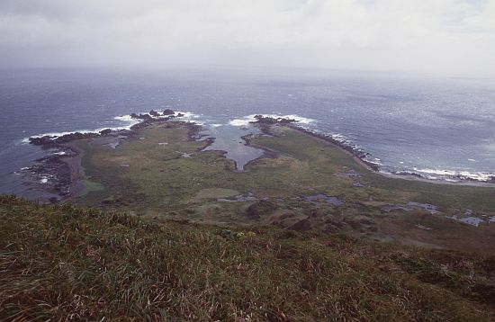
©AAD, Copyright Commonwealth of Australia 1999
- Catalogue id
- 4639C2
- Photographer
- Main, Dale
Map
Source
Location Method:
Topographic data
Source Name:
Macquarie Island Vegetation and Drainage Structure Data Set,Mac Island Contours from AIRSAR Aug 2000
Source Identifier:
MIvegmap,macca_contour_gis
Source Scale:
1:25000
Source Institution:
Australian Antarctic Division
Source Person:
Brolsma
Source Publisher:
Australian Antarctic Division
Remote sensing:
NASA AIRSAR DEM Metadata record - [macca_dem_gis]
Macquarie Island Topopoly GIS Dataset. [macca_topopoly_gis]
Comments
NoneApproval status
Status:
Official
Date approved:
Unknown
Display Scales
Note These display scales were chosen for use by Australia, with an emphasis on East Antarctica.
For example, selecting 'Aus_display_scale_20M' would only return names that would appear on a 1:20 million scale map.
For example, selecting 'Aus_display_scale_20M' would only return names that would appear on a 1:20 million scale map.
| Aus_display_scale_20M: | No | Aus_display_scale_10M: | No | ||
| Aus_display_scale_5M: | No | Aus_display_scale_2M: | No | ||
| Aus_display_scale_1M: | No | Aus_display_scale_500k: | No | ||
| Aus_display_scale_250k: | No | Aus_display_scale_100k: | No | ||
| Aus_display_scale_50k: | Yes | Aus_display_scale_25k: | No | ||
| Aus_display_scale_10k: | No | Aus_display_scale_5k: | No | ||
| Aus_display_scale_1k: | No |
Related information
Biodiversity
View
fauna,
flora or
both
within 1.0 degree of this location
Place names
View
Australian or
international
place names within 1.0 degree of this location.