Name details
Breid Basin
Breid Basin (The name as it would appear in a gazetteer)
Breid Basin (The name as it would appear on a map)
If this information is incorrect, please e-mail mapping@aad.gov.au
Feature type: Basin
Origin
This name originates from Australia. It is part of the Australian Antarctic Gazetteer and the SCAR Composite Gazetteer of Antarctica.
Narrative
The eastern part of Long Fjord, Vestfold Hills. It is connected to the main part of the fjord by narrows and is probably less saline. Photographed by the Lars Christensen Expedition (1936-37) and mapped as a lake by Norwegian cartographers, who called it Breidvatnet (The Broad Lake). The feature was also photographed by USN Operation Highjump (1946-47), the Soviet Antarctic Expedition in 1956 and ANARE in 1957 and 1958. This part of Long Fjord has been traversed many times by ANARE parties on their way to and from the remote station Platcha.
Named For
Photographed by the Lars Christensen Expedition (1936-37) and mapped as a lake by Norwegian cartographers, who called it Breidvatnet (The Broad Lake).
Location
Images
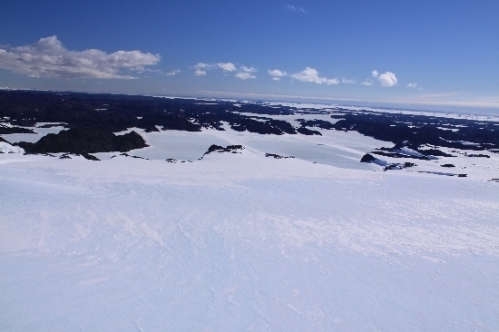
©Belinda Reynolds 2009
- Catalogue id
- IA21853
- Caption
- Breid Basin, Vestfold Hills. Taken from helicopter at height of 1400 feet. Looking North.
- Photographer
- Reynolds, Belinda
Map
Source
Comments
Metadata for coordinates and origin of topographic data.Approval status
Display Scales
For example, selecting 'Aus_display_scale_20M' would only return names that would appear on a 1:20 million scale map.
| Aus_display_scale_20M: | No | Aus_display_scale_10M: | No | ||
| Aus_display_scale_5M: | No | Aus_display_scale_2M: | No | ||
| Aus_display_scale_1M: | No | Aus_display_scale_500k: | No | ||
| Aus_display_scale_250k: | No | Aus_display_scale_100k: | Yes | ||
| Aus_display_scale_50k: | Yes | Aus_display_scale_25k: | Yes | ||
| Aus_display_scale_10k: | No | Aus_display_scale_5k: | No | ||
| Aus_display_scale_1k: | No |
Related information
Biodiversity
View
fauna,
flora or
both
within 1.0 degree of this location
Place names
View
Australian or
international
place names within 1.0 degree of this location.