Name details
Clemence Fjord
Clemence Fjord (The name as it would appear in a gazetteer)
Clemence Fjord (The name as it would appear on a map)
If this information is incorrect, please e-mail mapping@aad.gov.au
Feature type: Fjord
Origin
This name originates from Australia. It is part of the Australian Antarctic Gazetteer and the SCAR Composite Gazetteer of Antarctica.
Narrative
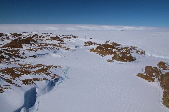
A fjord, extending NW-SE between Fisher Island and Lied Promontory in the Larsemann Hills. Plotted from air photographs taken by the Lars Christensen Expedition 1936-37 and called Broknesdalen (the Broken Cape Valley).
Named For
Named after Sqd Ldr Peter Clemence, Officer commanding the RAAF Flight at Mawson in 1957, who made landings in the Larsemann Hills in support of the field party there.
Location
Images
©Adam Christensen 2009
- Catalogue id
- IA21764
- Caption
- Clemence Fjord, Larsemann Hills. Taken from helicopter at height of 1000 feet. Looking Southwest.
- Photographer
- Christensen, Adam
Map
Source
Comments
NoneApproval status
Display Scales
For example, selecting 'Aus_display_scale_20M' would only return names that would appear on a 1:20 million scale map.
| Aus_display_scale_20M: | No | Aus_display_scale_10M: | No | ||
| Aus_display_scale_5M: | No | Aus_display_scale_2M: | No | ||
| Aus_display_scale_1M: | No | Aus_display_scale_500k: | No | ||
| Aus_display_scale_250k: | No | Aus_display_scale_100k: | No | ||
| Aus_display_scale_50k: | No | Aus_display_scale_25k: | Yes | ||
| Aus_display_scale_10k: | No | Aus_display_scale_5k: | No | ||
| Aus_display_scale_1k: | No |
Related information
Biodiversity
View
fauna,
flora or
both
within 1.0 degree of this location
Place names
View
Australian or
international
place names within 1.0 degree of this location.