Name details
Crooked Fjord
Crooked Fjord (The name as it would appear in a gazetteer)
Crooked Fjord (The name as it would appear on a map)
If this information is incorrect, please e-mail mapping@aad.gov.au
Feature type: Fjord
Origin
This name originates from Australia. It is part of the Australian Antarctic Gazetteer and the SCAR Composite Gazetteer of Antarctica.
Names that other countries have for this feature:
- Krok Fjord (United States of America)
- Krokfjorden (Russia)
Narrative
Crooked Fjord is a marine inlet extending from Omega Cove to the western extent of Mule Peninsula, a length of about 11km long. It lies between the Sørsdal Glacier and Mule Peninsula, in the southern part of the Vestfold Hills.
Named For
Plotted from air photographs taken by the Lars Christensen Expedition (1936-37) and called Krokfjorden (The Crooked Fjord) by Norwegian cartographers.
Location
Images
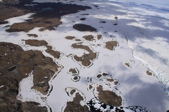
©Belinda Reynolds 2009
- Catalogue id
- IA21874
- Caption
- Crooked Fjord, Vestfold Hills. Taken from helicopter at height of 2500 feet. Looking East.
- Photographer
- Reynolds, Belinda
Map
Source
Comments
Metadata for coordinates and origin of topographic data.Approval status
Display Scales
For example, selecting 'Aus_display_scale_20M' would only return names that would appear on a 1:20 million scale map.
| Aus_display_scale_20M: | No | Aus_display_scale_10M: | No | ||
| Aus_display_scale_5M: | No | Aus_display_scale_2M: | No | ||
| Aus_display_scale_1M: | No | Aus_display_scale_500k: | No | ||
| Aus_display_scale_250k: | No | Aus_display_scale_100k: | Yes | ||
| Aus_display_scale_50k: | Yes | Aus_display_scale_25k: | Yes | ||
| Aus_display_scale_10k: | No | Aus_display_scale_5k: | No | ||
| Aus_display_scale_1k: | No |
Related information
Biodiversity
View
fauna,
flora or
both
within 1.0 degree of this location
Place names
View
Australian or
international
place names within 1.0 degree of this location.