Name details
Davis Anchorage
Davis Anchorage (The name as it would appear in a gazetteer)
Davis Anchorage (The name as it would appear on a map)
If this information is incorrect, please e-mail mapping@aad.gov.au
Feature type: Anchorage
Origin
This name originates from Australia. It is part of the Australian Antarctic Gazetteer and the SCAR Composite Gazetteer of Antarctica.
Names that other countries have for this feature:
- Davis Anchorage (United States of America)
Narrative
The body of water, with general depths of 18 to 24 m extending about 2 km southwards from the southern point of Anchorage Island, Vestfold Hills. It is bounded on the west by a line joining Krat Rocks and Newman Shoal, and on the east by the rocks and shoal water extending for about 1 km offshore from Davis station. This anchorage has been used by ANARE relief expedition ships since 1957. A hydrographic survey was carried out in 1961 by D'A T Gale, hydrographic surveyor with the ANARE Expedition on MV Thala Dan led by D R Styles.
Named For
Location
Images
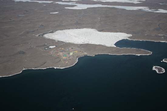
©Nathan Saunders 2009
- Catalogue id
- IA21878
- Caption
- Davis Anchorage, Vestfold Hills. Taken from helicopter at height of 2500 feet. Looking South.
- Photographer
- Saunders, Nathan
Map
Source
Comments
Metadata for coordinates and origin of topographic data.Approval status
Display Scales
For example, selecting 'Aus_display_scale_20M' would only return names that would appear on a 1:20 million scale map.
| Aus_display_scale_20M: | No | Aus_display_scale_10M: | No | ||
| Aus_display_scale_5M: | No | Aus_display_scale_2M: | No | ||
| Aus_display_scale_1M: | No | Aus_display_scale_500k: | No | ||
| Aus_display_scale_250k: | No | Aus_display_scale_100k: | No | ||
| Aus_display_scale_50k: | No | Aus_display_scale_25k: | No | ||
| Aus_display_scale_10k: | No | Aus_display_scale_5k: | No | ||
| Aus_display_scale_1k: | No |
Related information
Biodiversity
View
fauna,
flora or
both
within 1.0 degree of this location
Place names
View
Australian or
international
place names within 1.0 degree of this location.