Name details
Boulder Hill
Boulder Hill (The name as it would appear in a gazetteer)
Boulder Hill (The name as it would appear on a map)
If this information is incorrect, please e-mail mapping@aad.gov.au
Feature type: Hill
Origin
This name originates from Australia. It is part of the Australian Antarctic Gazetteer and the SCAR Composite Gazetteer of Antarctica.
Narrative
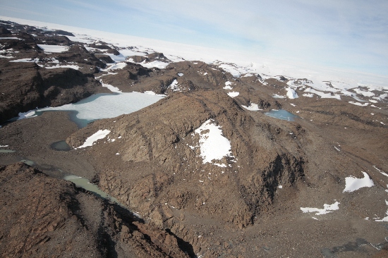
A big hill (158.0 m) that overlooks the eastern end of Crooked Lake, in the Vestfold Hills. The summit is probably the highest isolated rock feature in the Vestfold Hills. A survey station NM/S 261 (a brass pin in the rock) was established in January 1979.
Named For
A huge boulder lies perched some 50-100 m south-east of the station mark. It measures approximately 4 m high by 3 m long by 3 m wide and is conspicuously silhouetted from almost all aspects.
Location
Images
©Nathan Saunders 2009
- Catalogue id
- IA21851
- Caption
- Boulder Hill, Vestfold Hills. Taken from helicopter at height of 1200 feet. Looking East.
- Photographer
- Saunders, Nathan
Map
Source
Comments
Metadata for coordinates and origin of topographic data.Approval status
Display Scales
For example, selecting 'Aus_display_scale_20M' would only return names that would appear on a 1:20 million scale map.
| Aus_display_scale_20M: | No | Aus_display_scale_10M: | No | ||
| Aus_display_scale_5M: | No | Aus_display_scale_2M: | No | ||
| Aus_display_scale_1M: | No | Aus_display_scale_500k: | No | ||
| Aus_display_scale_250k: | No | Aus_display_scale_100k: | No | ||
| Aus_display_scale_50k: | Yes | Aus_display_scale_25k: | Yes | ||
| Aus_display_scale_10k: | Yes | Aus_display_scale_5k: | No | ||
| Aus_display_scale_1k: | No |
Related information
Biodiversity
View
fauna,
flora or
both
within 1.0 degree of this location
Place names
View
Australian or
international
place names within 1.0 degree of this location.