Ufs Island
Ufs Island (The name as it would appear in a gazetteer)
Ufs Island (The name as it would appear on a map)
If this information is incorrect, please e-mail mapping@aad.gov.au
Place ID: 15157
Name ID: 1023
Feature type:
Island
Origin
This name originates from Australia.
It is part of the
Australian Antarctic Gazetteer and the SCAR Composite Gazetteer of Antarctica.
Names that other countries have for this feature:
Narrative
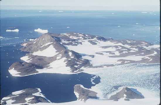
A rocky island about 4 km across lying on the eastern side of Howard Bay.
Named For
The northern part of the island was discovered and named Cape Simpson by Sir Douglas Mawson, leader of BANZARE in February, 1931. Mapped as an island and called Ufsøy (Bluff Island) by Norwegian cartographers from air photographs taken by the Lars Christensen Expedition (1936-37).
Location
Latitude:
67° 28' 40.4" S
-67.47790°
Unknown precision
Longitude:
61° 08' 06.7" E
61.13520°
Unknown precision
Altitude:
Not recorded
Unknown precision
Images
©AAD, Copyright Commonwealth of Australia 1972
- Catalogue id
- 516A5
- Caption
- In the eastern part of Howard Bay. Called Ufsoy by the Norwegians, meaning Bluff Island
- Photographer
- Manning, John
Map
Source
Source Institution:
Unknown
Source Publisher:
Unknown
Remote sensing:
Not Applicable
Comments
None
Approval status
Date approved:
18-Feb-1958
Related information