Barrier Island
Barrier Island (The name as it would appear in a gazetteer)
Barrier Island (The name as it would appear on a map)
If this information is incorrect, please e-mail mapping@aad.gov.au
Place ID: 940
Name ID: 1068
Feature type:
Island
Origin
This name originates from Australia.
It is part of the
Australian Antarctic Gazetteer and the SCAR Composite Gazetteer of Antarctica.
Names that other countries have for this feature:
Narrative
An island about 1.5 km long, elongated north-south in the entrance to Tryne Sound in the northern part of the Vestfold Hills. Mapped by Norwegian cartographers from air photographs taken by the Lars Christensen Expedition (1936-37).
Named For
First visited by an ANARE sledging party led by Bruce H. Stinear in April, 1957, and so named because the island appeared to form a barrier to the passage of icebergs up Tryne Fjord.
Location
Latitude:
68° 25' 50.2" S
-68.43061°
Accurate to 30m
Longitude:
78° 23' 46.0" E
78.39611°
Accurate to 30m
Altitude:
27.5 m
Accurate to 5m
Images
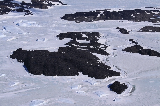
©Belinda Reynolds 2009
- Catalogue id
- IA21846
- Caption
- Barrier Island, Vestfold Hills. Taken from helicopter at height of 1000 feet. Looking West.
- Photographer
- Reynolds, Belinda
Map
Source
Location Method:
Topographic data
Source Name:
Vestfold Hills Topographic GIS Dataset
Source Identifier:
vest_hills_gis
Source Institution:
Australian Antarctic Division
Source Publisher:
Australian Antarctic Division
Remote sensing:
Not Applicable
Comments
Metadata for coordinates and origin of topographic data.
Approval status
Date approved:
29-Apr-1958
Related information