Fold Lake
Fold Lake (The name as it would appear in a gazetteer)
Fold Lake (The name as it would appear on a map)
If this information is incorrect, please e-mail mapping@aad.gov.au
Place ID: 4779
Name ID: 1206
Feature type:
Water body
Origin
This name originates from Australia.
It is part of the
Australian Antarctic Gazetteer and the SCAR Composite Gazetteer of Antarctica.
Narrative
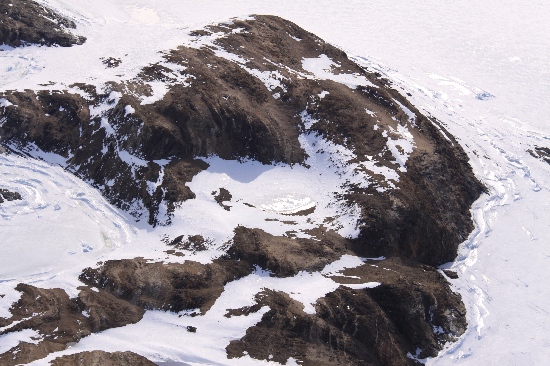
A small, oval lake on Manning Island in the Larsemann Hills.
Named For
Named by the 1986-87 ANARE Field party because of marked folding in the sides of the valley in which the lake is situated.
Location
Latitude:
69° 21' 28.4" S
-69.35789°
Accurate to 25m
Longitude:
76° 19' 14.3" E
76.32063°
Accurate to 25m
Altitude:
12 m
Accurate to 10m
Images
©Rick Oates 2009
- Catalogue id
- IA21774
- Caption
- Fold Lake, Larsemann Hills. Taken from helicopter at height of 1700 feet. Looking East.
- Photographer
- Oates, Rick
Map
Source
Source Name:
Larsemann Hills 1:25000 Topographic GIS Dataset
Source Identifier:
Lars25K
Source Institution:
Australian Antarctic Division
Source Publisher:
Australian Antarctic Division
Remote sensing:
Not Applicable
Comments
None
Approval status
Date approved:
24-Nov-1987
Related information