Ardery Island
Ardery Island (The name as it would appear in a gazetteer)
Ardery Island (The name as it would appear on a map)
If this information is incorrect, please e-mail mapping@aad.gov.au
Place ID: 476
Name ID: 121890
Feature type:
Island
(5)
Origin
This name originates from United States of America.
It is part of the
United States Gazetteer and the SCAR Composite Gazetteer of Antarctica.
Names that other countries have for this feature:
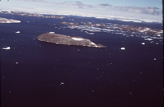
Narrative
Steep, rocky island, 0.6 mi long, lying 1.1 mi W of Odbert Island in the Windmill Islands. First mapped from air photos taken by USN Operation HighJump and Operation Windmill in 1947 and 1948. Named by the US-ACAN for Maj. E.R. Ardery, Army Corps of Engineers observer who assisted USN Operation Windmill parties in establishing astronomical control stations between Wilhelm II Coast and Budd Coast during the 1947-48 season.
Named For
Location
Latitude:
66° 22' 00.0" S
-66.36667°
Unknown precision
Longitude:
110° 27' 00.0" E
110.45000°
Unknown precision
Altitude:
Not recorded
Unknown precision
Images
©Butler, Rowan 1985
- Catalogue id
- 236D5
- Photographer
- Butler, Rowan
Map
Source
Source Institution:
Unknown
Source Publisher:
Unknown
Remote sensing:
Not Applicable
Comments
None
Approval status
Date approved:
1-Jan-1956
Related information