Williams Lake
Williams Lake (The name as it would appear in a gazetteer)
Williams Lake (The name as it would appear on a map)
If this information is incorrect, please e-mail mapping@aad.gov.au
Place ID: 16083
Name ID: 1240
Feature type:
Water body
Origin
This name originates from Australia.
It is part of the
Australian Antarctic Gazetteer and the SCAR Composite Gazetteer of Antarctica.
Narrative
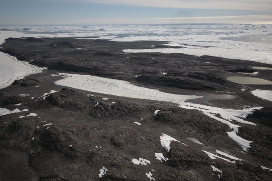
Williams Lake is an oval shaped saline lake near the western end of Long Peninsula in the Vestfold Hills. It is approximately 1 km long and 250 m wide. The lake is separated from Bulatnaya Bay in the north and Long Fjord in the south by low divides. The surface of the lake is 0.5 - 1m above the high water mark. Water has not been observed flowing into the lake from the ocean, but was flowing from the lake into Long Fjord on 16 January 1988. The maximum recorded depth in Williams Lake is 7 m but the lake is quite large and there could well be deeper points than so far discovered. The salinity of Lake Williams ranges from near seawater salinity near the surface to over 100gL-1 at 7m. Lake water is anoxic beneath 6 m. The lake appears to be permanently stratified and should thus be considered meromictic.
Named For
It is named after Richard Williams who was a wintering limnologist at Davis in 1974. He contributed significantly to the early limnology of the Vestfold Hills and as a scientist with the Australian Antarctic Division has continued to contribute to our knowledge of the biology of the Antarctic region in the years since.
Location
Latitude:
68° 28' 50.5" S
-68.48069°
Accurate to 30m
Longitude:
78° 09' 20.9" E
78.15581°
Accurate to 30m
Altitude:
3 m
Accurate to 5m
Images
©Nathan Saunders 2009
- Catalogue id
- IA22042
- Caption
- Williams Lake, Vestfold Hills. Taken from helicopter at height of 1200 feet. Looking West.
- Photographer
- Saunders, Nathan
Map
Source
Location Method:
Topographic data
Source Name:
Vestfold Hills Topographic GIS Dataset
Source Identifier:
Metadata (
vest_hills_gis - Vestfold Hills 1:25000 Topographic GIS Dataset )
Source Institution:
Australian Antarctic Division
Source Publisher:
Australian Antarctic Division
Remote sensing:
Not Applicable
Comments
Metadata for coordinates and origin of topographic data.
Approval status
Date approved:
27-Apr-1995
Related information