Krok Fjord
Krok Fjord (The name as it would appear in a gazetteer)
Krok Fjord (The name as it would appear on a map)
If this information is incorrect, please e-mail mapping@aad.gov.au
Place ID: 7845
Name ID: 127614
Feature type:
Fjord
(3)
Origin
This name originates from United States of America.
It is part of the
United States Gazetteer and the SCAR Composite Gazetteer of Antarctica.
Names that other countries have for this feature:
Narrative
A narrow sinuous fjord, 11 mi long, between Mule Peninsula and Sorsdal Glacier Tongue, at the south end of the Vestfold Hills. Mapped from air photos taken by the Lars Christensen Expedition (1936-37) and named Krokfjorden (the crooked fjord).
Named For
Location
Latitude:
68° 40' 00.0" S
-68.66667°
Unknown precision
Longitude:
78° 00' 00.0" E
78.00000°
Unknown precision
Altitude:
Not recorded
Unknown precision
Images
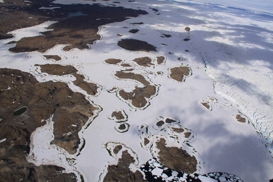
©Belinda Reynolds 2009
- Catalogue id
- IA21874
- Caption
- Crooked Fjord, Vestfold Hills. Taken from helicopter at height of 2500 feet. Looking East.
- Photographer
- Reynolds, Belinda
Map
Source
Source Institution:
Unknown
Source Publisher:
Unknown
Remote sensing:
Not Applicable
Comments
None
Approval status
Date approved:
1-Jan-1965
Related information