Mikkelsen Peak
Mikkelsen Peak (The name as it would appear in a gazetteer)
Mikkelsen Peak (The name as it would appear on a map)
If this information is incorrect, please e-mail mapping@aad.gov.au
Place ID: 9550
Name ID: 128880
Feature type:
Peak
(2d)
Origin
This name originates from United States of America.
It is part of the
United States Gazetteer and the SCAR Composite Gazetteer of Antarctica.
Names that other countries have for this feature:
Narrative
The highest peak, 420 m, of the Scullin Monolith in Mac. Robertson Land. In January and February 1931 several Norwegian whale catchers, exploring along this coast, made sketches of the shore from their vessels and named this mountain for Capt. Klarius Mikkelsen, master of the Torlyn.
Named For
Location
Latitude:
67° 47' 00.0" S
-67.78333°
Unknown precision
Longitude:
66° 43' 00.0" E
66.71667°
Unknown precision
Altitude:
420 m
Unknown precision
Images
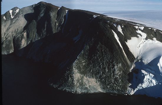
©AAD, Copyright Commonwealth of Australia 1972
- Catalogue id
- 515D2
- Caption
- A Crescent shaped rock west of Torlyn Mountain on the Mawson Coast. Douglas Mawson landed on it in a plane on February 13, 1931, during the BANZARE, and named it for J.H. Scullin, Prime Minister of Australia. In Jan-Feb 1931 Norwegians charted it and named it Mount Klarius Mikkelsen. The Mawson naming has become accepted and Mikkelsen Peak is now the highest feature on the monolith.
- Photographer
- Manning, John
Map
Source
Source Institution:
Unknown
Source Publisher:
Unknown
Remote sensing:
Not Applicable
Comments
None
Approval status
Date approved:
1-Jan-1947
Related information