Mount Ward
Ward, Mount (The name as it would appear in a gazetteer)
Mount Ward (The name as it would appear on a map)
If this information is incorrect, please e-mail mapping@aad.gov.au
Place ID: 15734
Name ID: 1459
Feature type:
Mountain
Origin
This name originates from Australia.
It is part of the
Australian Antarctic Gazetteer and the SCAR Composite Gazetteer of Antarctica.
Names that other countries have for this feature:
Narrative
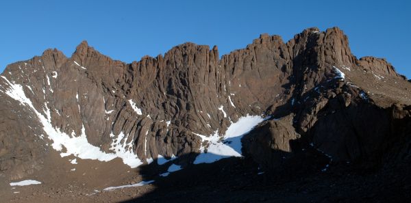
An isolated peak, 976m above sea level, in the southern part of the North Masson Range in Mac.Robertson Land. Discovered by Sir Douglas Mawson in 1930. Climbed by an ANARE party led by J. Béchervaise in January 1956. Named for J.L. Ward, radio operator at Mawson in 1955.
Named For
Location
Latitude:
67° 47' 17.9" S
-67.78831°
Accurate to 30m
Longitude:
62° 49' 05.2" E
62.81811°
Accurate to 30m
Altitude:
975.6 m
Accurate to 20m
Images
©Wade Fairley 2005
- Catalogue id
- IA16594
- Caption
- Mount Ward
- Photographer
- Fairley, Wade
Map
Source
Source Name:
Framnes Mountains 1:25000 Topographic GIS Dataset
Source Identifier:
Metadata (
fram25k - Framnes Mountains 1:25000 Topographic GIS Dataset )
Source Institution:
Australian Antarctic Division
Source Publisher:
Australian Antarctic Division
Remote sensing:
Not Applicable
Comments
None
Approval status
Date approved:
4-Sep-1956
Related information