Mount Riiser-Larsen
Riiser-Larsen, Mount (The name as it would appear in a gazetteer)
Mount Riiser-Larsen (The name as it would appear on a map)
If this information is incorrect, please e-mail mapping@aad.gov.au
Place ID: 12148
Name ID: 1609
Feature type:
Mountain
Origin
This name originates from Australia.
It is part of the
Australian Antarctic Gazetteer and the SCAR Composite Gazetteer of Antarctica.
Names that other countries have for this feature:
Narrative
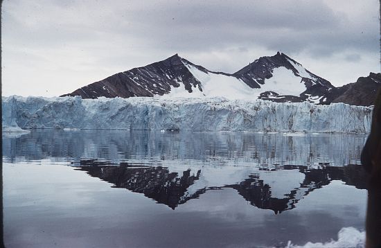
A prominent peak of the Tula Mountains, on the eastern side of Amundsen Bay in Enderby Land. Discovered on 13 or 14 January, 1930, by BANZARE (1929-31). Named lby Sir Douglas Mawson after Capt. Hjalmar Riiser-Larsen, leader of a Norwegian expedition in the Norvegia (1929-30), which also explored the area. An ANARE party led by Phillip Law made a landing from a motor-launch at the foot of the mountain on 14 February, 1958.
Named For
Location
Latitude:
66° 46' 17.7" S
-66.77158°
Accurate to 20m
Longitude:
50° 46' 12.8" E
50.77022°
Accurate to 20m
Altitude:
Not recorded
Unknown precision
Images
©AAD, Copyright Commonwealth of Australia 1961
- Catalogue id
- 4631C3
- Photographer
- Newton, Geoffrey (Geoff)
Map
Source
Location Method:
Surveyed
Source Name:
AADCC Survey Control Data Base
Source Identifier:
Survey Control (
NMS220 - Mount Riiser-Larsen)
Source Institution:
Australian Antarctic Division
Source Publisher:
Australian Antarctic Division
Remote sensing:
Not Applicable
Comments
None
Approval status
Related information