Broknes
Broknes (The name as it would appear in a gazetteer)
Broknes (The name as it would appear on a map)
If this information is incorrect, please e-mail mapping@aad.gov.au
Place ID: 1891
Name ID: 2117
Feature type:
Peninsula
Origin
This name originates from Australia.
It is part of the
Australian Antarctic Gazetteer and the SCAR Composite Gazetteer of Antarctica.
Narrative
A large rock peninsula on the eastern extremity of the Larsemann Hills.
Named For
Plotted from air photographs taken by the Lars Christensen Expedition, 1936-37 and called Broknes (Broken Cape) by Norwegian cartographers. The peninsula is broken by Nella Fjord.
Location
Latitude:
69° 23' 28.4" S
-69.39123°
Accurate to 25m
Longitude:
76° 20' 47.0" E
76.34639°
Accurate to 25m
Altitude:
148 m
Accurate to 10m
Images
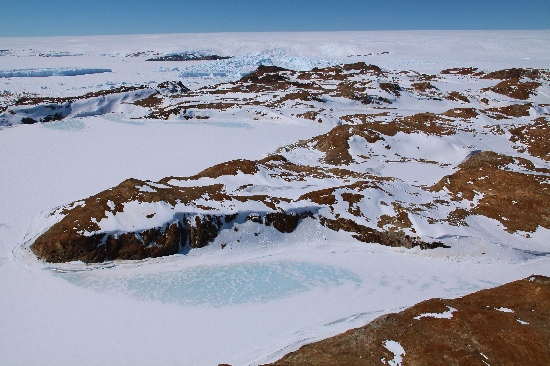
©Adam Christensen 2009
- Catalogue id
- IA21759
- Caption
- Broknes, Larsemann Hills. Taken from helicopter at height of 1000 feet. Looking Southeast.
- Photographer
- Christensen, Adam
Map
Source
Source Name:
Larsemann Hills 1:25000 Topographic GIS Dataset
Source Identifier:
Lars25K
Source Institution:
Australian Antarctic Division
Source Publisher:
Australian Antarctic Division
Remote sensing:
Not Applicable
Comments
None
Approval status
Date approved:
24-Nov-1987
Related information