Burke Basin
Burke Basin (The name as it would appear in a gazetteer)
Burke Basin (The name as it would appear on a map)
If this information is incorrect, please e-mail mapping@aad.gov.au
Place ID: 2073
Name ID: 33
Feature type:
Basin
Origin
This name originates from Australia.
It is part of the
Australian Antarctic Gazetteer and the SCAR Composite Gazetteer of Antarctica.
Narrative
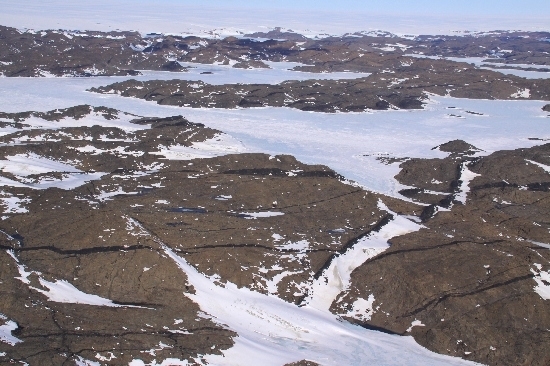
The basin is an approximately triangular shaped basin of Taynaya Bay in the Vestfold Hills. It is 1 km long and 0.8km wide. The maximum known depth of the basin is 32 m although deeper spots may occur. The water of the basin is stratified, being near seawater salinity at the surface and increasing to circa 70 gL-1 at 30 m. Stratification begins at a depth of 10 m. The basin is one of the approximately 7 stratified marine basins that occur in the Vestfold Hills. Such basins are rare and these are probably the only known examples from Antarctica. The biology of Burke Basin is likely to be similar to the rest of Taynaya Bay and the ocean in the upper water, but like meromictic lakes in the lower water. The anoxic water probably supports dense populations of sulphate reducing bacteria beneath a layer of photosynthetic sulphur bacteria.
Named For
Burke Basin is named after Dr Chris Burke who wintered at Davis in 1983 studying the photosynthetic sulphur bacteria of the meromictic lakes and stratified fjords of the Vestfold Hills.
Location
Latitude:
68° 27' 51.1" S
-68.46419°
Accurate to 30m
Longitude:
78° 17' 45.2" E
78.29589°
Accurate to 30m
Altitude:
0 m
Unknown precision
Images
©Belinda Reynolds 2009
- Catalogue id
- IA21858
- Caption
- Burke Basin, Vestfold Hills. Taken from helicopter at height of 1200 feet. Looking Southwest.
- Photographer
- Reynolds, Belinda
Map
Source
Location Method:
Topographic data
Source Name:
Vestfold Hills Topographic GIS Dataset
Source Identifier:
vest_hills_gis
Source Institution:
Australian Antarctic Division
Source Publisher:
Australian Antarctic Division
Remote sensing:
Not Applicable
Comments
Metadata for coordinates and origin of topographic data.
Approval status
Date approved:
27-Apr-1995
Related information