Talg Falls
Talg Falls (The name as it would appear in a gazetteer)
Talg Falls (The name as it would appear on a map)
If this information is incorrect, please e-mail mapping@aad.gov.au
Place ID: 14399
Name ID: 419
Feature type:
Fall
Origin
This name originates from Australia.
It is part of the
Australian Antarctic Gazetteer and the SCAR Composite Gazetteer of Antarctica.
Narrative
A waterfall over the ice in the Vestfold Hills, where the Talg River runs over a 6 m ice cliff. Talg is Arabic for "ice".
Named For
Location
Latitude:
68° 37' 37.6" S
-68.62710°
Accurate to 30m
Longitude:
78° 22' 41.9" E
78.37830°
Accurate to 30m
Altitude:
28 m
Accurate to 5m
Images
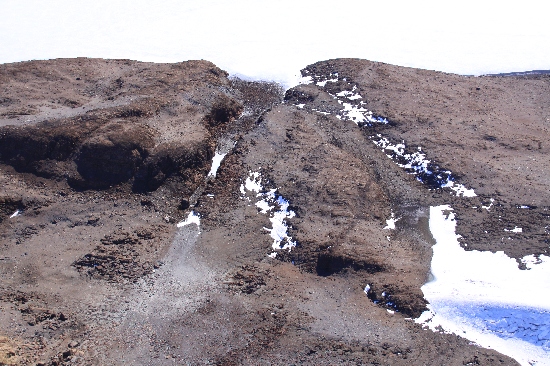
©Richard 'Tubby' Seton 2009
- Catalogue id
- IA22004
- Caption
- Talg Falls, Vestfold Hills. Taken from helicopter at height of 1200 feet. Looking South.
- Photographer
- Seton, Richard
Map
Source
Location Method:
Topographic data
Source Name:
Vestfold Hills Topographic GIS Dataset
Source Identifier:
vest_hills_gis
Source Institution:
Australian Antarctic Division
Source Publisher:
Australian Antarctic Division
Remote sensing:
Not Applicable
Comments
Metadata for coordinates and origin of topographic data.
Approval status
Date approved:
15-Mar-1984
Related information