Polygon Gorge
Polygon Gorge (The name as it would appear in a gazetteer)
Polygon Gorge (The name as it would appear on a map)
If this information is incorrect, please e-mail mapping@aad.gov.au
Place ID: 11449
Name ID: 624
Feature type:
Gorge
Origin
This name originates from Australia.
It is part of the
Australian Antarctic Gazetteer and the SCAR Composite Gazetteer of Antarctica.
Narrative
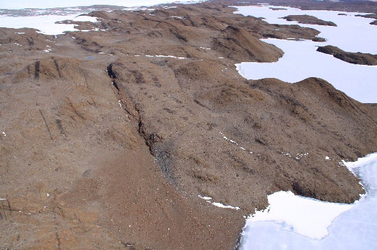
A narrow south-north trending gorge from Polygon Valley to Crooked Lake in the Vestfold Hills. It is about 600 m long, 10-15 m wide and up to 25 m deep. This is the western of two gorges at this end of Crooked Lake.
Named For
Named for its association with Polygon Valley.
Location
Latitude:
68° 36' 37.4" S
-68.61040°
Accurate to 30m
Longitude:
78° 28' 46.2" E
78.47950°
Accurate to 30m
Altitude:
50 m
Accurate to 5m
Images
©Richard 'Tubby' Seton 2009
- Catalogue id
- IA21978
- Caption
- Polygon Gorge, Vestfold Hills. Taken from helicopter at height of 1000 feet. Looking South.
- Photographer
- Seton, Richard
Map
Source
Location Method:
Topographic data
Source Name:
Vestfold Hills Topographic GIS Dataset
Source Identifier:
vest_hills_gis
Source Institution:
Australian Antarctic Division
Source Publisher:
Australian Antarctic Division
Remote sensing:
Not Applicable
Comments
Metadata for coordinates and origin of topographic data.
Approval status
Date approved:
3-Dec-1984
Related information