Grimmia Gorge
Grimmia Gorge (The name as it would appear in a gazetteer)
Grimmia Gorge (The name as it would appear on a map)
If this information is incorrect, please e-mail mapping@aad.gov.au
Place ID: 5703
Name ID: 626
Feature type:
Gorge
Origin
This name originates from Australia.
It is part of the
Australian Antarctic Gazetteer and the SCAR Composite Gazetteer of Antarctica.
Narrative
A narrow south-north trending gorge in the Vestfold Hills approximately 20 m wide and 20-30 m deep which runs into a gravel bank at the eastern end of Crooked Lake. There is a small waterfall on the eastern side at the southern end. It is the most easterly of two south-north gorges.
Named For
Named after well developed beds of moss (Grimmia) at the exit to the gorge.
Location
Latitude:
68° 36' 23.4" S
-68.60650°
Accurate to 30m
Longitude:
78° 29' 35.2" E
78.49311°
Accurate to 30m
Altitude:
23 m
Accurate to 5m
Images
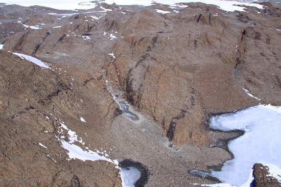
©Richard 'Tubby' Seton 2009
- Catalogue id
- IA21897
- Caption
- Grimmia Gorge, Vestfold Hills. Taken from helicopter at height of 900 feet. Looking Southwest.
- Photographer
- Seton, Richard
Map
Source
Location Method:
Topographic data
Source Name:
Vestfold Hills Topographic GIS Dataset
Source Identifier:
Metadata (
vest_hills_gis - Vestfold Hills 1:25000 Topographic GIS Dataset )
Source Institution:
Australian Antarctic Division
Source Publisher:
Australian Antarctic Division
Remote sensing:
Not Applicable
Comments
Metadata for coordinates and origin of topographic data.
Approval status
Date approved:
26-Jul-1983
Related information