Vestfold Hills
Vestfold Hills (The name as it would appear in a gazetteer)
Vestfold Hills (The name as it would appear on a map)
If this information is incorrect, please e-mail mapping@aad.gov.au
Place ID: 15439
Name ID: 718
Feature type:
Hill
Origin
This name originates from Australia.
It is part of the
Australian Antarctic Gazetteer and the SCAR Composite Gazetteer of Antarctica.
Names that other countries have for this feature:
Narrative
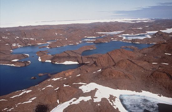
An area of ice-free mainland rock and off-shore islands covering an area of about 512 square km on the Ingrid Christensen Coast. The rounded hills are mostly between 30 and 100 m above sea level and have a maximum height of 159 m. Discovered and named by a Norwegian expedition under Capt. Klarius Mikkelsen in 1935, when a brief landing was made in the northern part of the area. Further brief landings were made by Lincoln Ellsworth in 1939. The Vestfold Hills were photographed from the air by the Lars Christensen Expedition (1936-37) and USN Operation Highjump (1946-47). Landings were made and exploration carried out in 1954 and 1955 by ANARE led by Phillip Law, who established Davis station in January, 1957. Named after Vestfold, a county in Norway.
Named For
Location
Latitude:
68° 33' 00.0" S
-68.55000°
Accurate to 30m
Longitude:
78° 15' 00.0" E
78.25000°
Accurate to 30m
Altitude:
159 m
Accurate to 5m
Images
©AAD, Copyright Commonwealth of Australia 1993
- Catalogue id
- 2274B1
- Photographer
- Goddard, Jane
Map
Source
Location Method:
Topographic data
Source Name:
Vestfold Hills Topographic GIS Dataset
Source Identifier:
Metadata (
vest_hills_gis - Vestfold Hills 1:25000 Topographic GIS Dataset )
Source Institution:
Australian Antarctic Division
Source Publisher:
Australian Antarctic Division
Remote sensing:
Not Applicable
Comments
Metadata for coordinates and origin of topographic data.
Approval status
Related information