Wyatt Earp Islands
Wyatt Earp Islands (The name as it would appear in a gazetteer)
Wyatt Earp Islands (The name as it would appear on a map)
If this information is incorrect, please e-mail mapping@aad.gov.au
Place ID: 16261
Name ID: 881
Feature type:
Island
Origin
This name originates from Australia.
It is part of the
Australian Antarctic Gazetteer and the SCAR Composite Gazetteer of Antarctica.
Names that other countries have for this feature:
Narrative
A small group of islands and rocks off the northern extremity of the Vestfold Hills, about 1 km north of Walkabout Rocks. Mapped from air photographs taken by the Lars Christensen Expedition (1936-37) and called Nxrsteholman by the Norwegian cartographers. On 9 January, 1939, a landing was made by Sir Rubert Wilkins at nearby Walkabout rocks from the Wyatt Earp, after which the islands were renamed.
Named For
Location
Latitude:
68° 21' 33.1" S
-68.35919°
Accurate to 30m
Longitude:
78° 32' 23.3" E
78.53981°
Accurate to 30m
Altitude:
43.5 m
Accurate to 5m
Images
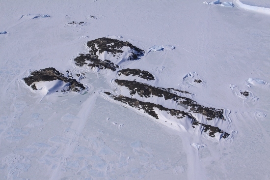
©Belinda Reynolds 2009
- Catalogue id
- IA22043
- Caption
- Wyatt Earp Islands, Vestfold Hills. Taken from helicopter at height of 1600 feet. Looking North.
- Photographer
- Reynolds, Belinda
Map
Source
Location Method:
Topographic data
Source Name:
Vestfold Hills Topographic GIS Dataset
Source Identifier:
vest_hills_gis
Source Institution:
Australian Antarctic Division
Source Publisher:
Australian Antarctic Division
Remote sensing:
Not Applicable
Comments
Metadata for coordinates and origin of topographic data.
Approval status
Date approved:
11-Aug-1958
Related information