Holl Island
Holl Island (The name as it would appear in a gazetteer)
Holl Island (The name as it would appear on a map)
If this information is incorrect, please e-mail mapping@aad.gov.au
Place ID: 6504
Name ID: 919
Feature type:
Island
Origin
This name originates from Australia.
It is part of the
Australian Antarctic Gazetteer and the SCAR Composite Gazetteer of Antarctica.
Names that other countries have for this feature:
Narrative
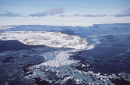
A rocky, roughly triangular island, about 95 m above sea level, at the south-west end of the Windmill Islands, off the Budd Coast, Wilkes Lane. Delineated from air photographs taken by USN Operation Highjump (1946-47) and its position fixed by USN Operation Windmill (1947-48). Named by USACAN after Lieut. Richard C. Holl, USNR, a member of a survey team which visited the island during Operation Windmill.
Named For
Location
Latitude:
66° 24' 38.5" S
-66.41069°
Accurate to 30m
Longitude:
110° 24' 32.0" E
110.40889°
Accurate to 30m
Altitude:
96 m
Accurate to 5m
Images
©AAD, Copyright Commonwealth of Australia 1998
- Catalogue id
- 3424B5
- Photographer
- Dixon, Grant
Map
Source
Location Method:
Topographic data
Source Name:
Windmill Islands 1:50000 GIS Dataset
Source Identifier:
Wind50K
Source Institution:
Australian Antarctic Division
Source Publisher:
Australian Antarctic Division
Remote sensing:
Not Applicable
Comments
None
Approval status
Related information