Easther Island
Easther Island (The name as it would appear in a gazetteer)
Easther Island (The name as it would appear on a map)
If this information is incorrect, please e-mail mapping@aad.gov.au
Place ID: 4041
Name ID: 976
Feature type:
Island
Origin
This name originates from Australia.
It is part of the
Australian Antarctic Gazetteer and the SCAR Composite Gazetteer of Antarctica.
Names that other countries have for this feature:
Narrative
An island in the Larsemann Hills which somewhat resembles the letter "H". Plotted from air photographs taken by the Lars Christensen Expedition 1936-37 and called Upsxy by Norwegian cartographers.
Named For
Named after Robert Easther, Officer-in-Charge at Davis in 1986, who helped to establish Law Base.
Location
Latitude:
69° 22' 28.3" S
-69.37452°
Accurate to 25m
Longitude:
76° 14' 11.9" E
76.23665°
Accurate to 25m
Altitude:
65 m
Accurate to 10m
Images
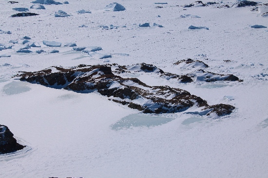
©Adam Christensen 2009
- Catalogue id
- IA21771
- Caption
- Easther Island, Larsemann Hills. Taken from helicopter at height of 1600 feet. Looking East.
- Photographer
- Christensen, Adam
Map
Source
Source Name:
Larsemann Hills 1:25000 Topographic GIS Dataset
Source Identifier:
Lars25K
Source Institution:
Australian Antarctic Division
Source Publisher:
Australian Antarctic Division
Remote sensing:
Not Applicable
Comments
None
Approval status
Date approved:
29-Sep-1988
Related information