Map 13752: CEP Tourism Study: Map 5 of 5
Southern Antarctic Peninsula
Map details
| Map Number | 13752 |
| Title | CEP Tourism Study: Map 5 of 5 Southern Antarctic Peninsula |
| Edition | 1 |
| Scale | 1 : 1 625 000 |
| Publication date | March 2010 |
| Publisher |
Australian Antarctic Division (Australia)
|
| Spatial coverage |
( -71.4137° -65.9087°)
,
( -61.5542° -65.9087°)
,
( -61.5542° -69.1320°)
( -71.4137° -69.1320°) |
| Projection | Polar Stereographic |
| Physical size | 22 x 15 cm |
| Notes |
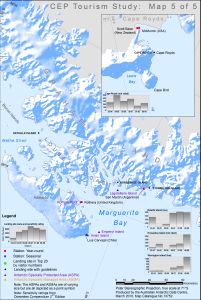
Map of southern Antarctic Peninsula and Ross Island showing landing sites in the top 20 most visited in Antarctica, the location of research stations and sites with ASPA/ASMA Management Plan and site guidelines. The change in the number of passenger landings from the 2003/04 to the 2008/09 season is graphed. This map was created for a tourism study, "Tourism and Non-governmental Activities in the Antarctic: Environmental Aspects and Impacts", for the Committee for Environmental Protection, May 2012. |
| Keywords | Antarctic Peninsula , Tourism , Landing Sites , Topographic |
Downloads
This is a digital map available for downloading.
Map Lists
No maps lists available.
Additional Information
| Horizontal datum | WGS84 |
Preview