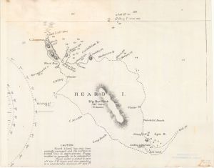
Map 14361: Islands in the Southern Indian Ocean. Heard and McDonald Islands. British Admiralty Chart (2317) no. 802
Map details
| Map Number | 14361 |
| Title | Islands in the Southern Indian Ocean. Heard and McDonald Islands. British Admiralty Chart (2317) no. 802 |
| Edition | 1 |
| Scale | Not Entered |
| Publication date | 1874 |
| Publisher |
The Admiralty (United Kingdom)
|
| Spatial coverage |
( 73.1667° -52.9000°)
,
( 73.9167° -52.9000°)
,
( 73.9167° -53.2083°)
( 73.1667° -53.2083°) |
| Projection | Not Given |
| Physical size | 44 x 56 cm |
| Notes | One of the first official maps of Heard Island, prepared by the British Admiralty after the visit of the Challenger Expedition. |
| Reference | Map details are available from the British Library |
| Keywords | Topographic |
Downloads
No downloads available.
Map Lists
This map belongs to the following lists. Use the link on the list to see all maps belonging to that list
Additional Information
Preview