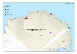
Map 14608: Year-round stations in the Australian Antarctic Territory
Map details
| Map Number | 14608 |
| Title | Year-round stations in the Australian Antarctic Territory |
| Edition | 1 |
| Scale | 1 : 15 000 000 |
| Publication date | September 2017 |
| Publisher |
Australian Antarctic Division (Australia)
|
| Spatial coverage |
( 36.4667° -61.8500°)
,
(172.7167° -61.8500°)
,
(172.7167° -87.6333°)
( 36.4667° -87.6333°) |
| Projection | Polar Stereographic |
| Physical size | 19.1 x 27.6 cm |
| Notes |
This map was one of a series (maps 14608 to 14612) created for a keynote address by the Director of the Australian Antarctic Division, Dr Nick Gales, for the Theo Murphy Australian Frontiers of Science Symposium, September 2017. Symbol size is an indication of peak population at the station based on information provided by the Council of Managers of National Antarctic Programs (COMNAP) as at 31 March 2017. |
| Keywords | - |
Downloads
This is a digital map available for downloading.
Map Lists
No maps lists available.
Additional Information
| Horizontal datum | WGS84 |
Preview